10 Earth Wonders from Space


Our Earth is full of wonders that fill us with awe, inspiration and humility. From far above in space where all illusions of boundary blur, one can truly admire the beauty of this planet that we call home. In this post we cover 10 fascinating features of our planet seen from high up in space. These images are made possible by Google Earth’s new studio programme which allows you to experience any corner of the world from the comfort of your home.
We may be in lockdown, but that should not stop us from exploring. Happy Earth Day 2020!
WORLD’S OLDEST DESERT


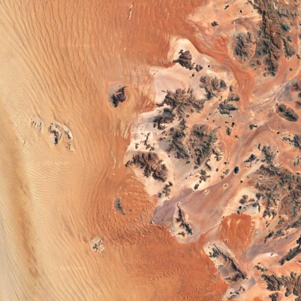
NAMIB DESERT
The Namib, at 55 million years old, is the world’s most ancient desert, as well as being one of the driest. Rainfall varies from 85mm in the west to just 2mm in the east – but the area is often covered by a thick fog, which allows plants and animals to survive thanks to the dew it creates. Another source of water are the rivers. Although the beds seem to be almost always parched, there is permanent water flow underground which creates linear “oases” on the surface.
“Namib” is the Nama word for “vast” – and this desert, stretching for 1,600km along Namibia’s coast, is certainly the embodiment of vastness.
WORLD’S LARGEST RAINFOREST


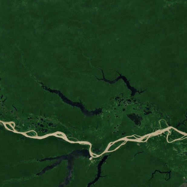
AMAZON FOREST
The Amazon rainforest is the largest tropical rainforest in the world and provides 20% of Earth’s oxygen. It is also known as the ‘Lungs of the planet’.
The Amazon is estimated to have 16,000 tree species and 390 billion individual trees. The rainforest is thought to have over 2.5 million species of insects. More than half the species in the Amazon rainforest are thought to live in the canopy. It shelters 10% of the world’s known biodiversity. One in five of all species of bird and fish live in the Amazon.
Around 400-500 indigenous American-indian tribes live in the Amazon rainforest. Around 50 of them have their own language and culture and have never had contact with the outer world. They are nomadic hunters and gatherers and constantly need to move around.
WORLD’S HIGHEST MOUNTAIN
MT. EVEREST
Nepalese call The Mount Everest as Sagarmatha which means ‘forehead in the sky’ and Tibetan call it Chomolungma which means ‘mother of the World’.
The height of Mount Everest is 29,029 feet or 8,848 Metres. According to one survey conducted, the height of Mt Everest increases every year by 4mm. This happens due to the collision of the Indian-Australian and the Eurasian plates.
The top of Mt. Everest is engulfed by the jet stream for a major part of the year, making climbing near impossible due to high winds and extreme sub zero temperatures. It is only when the winds die down in May and again for a short period in September, that we have a so called ‘Summit Window’, when conditions are safe enough for climbers to try and reach the summit.
WORLD’S LONGEST RIVER
RIVER NILE
Found in northeast Africa, the Nile is the longest river in the world – stretching a massive 6,695km!
The Nile has been an important source of life for people throughout history. Around 5,000 years ago, the Ancient Egyptians relied on the Nile for fresh water, food and transportation. This fascinating river remains an invaluable source of life for Egyptians to this day. More than 95% of the country’s population depend on its water and live within a few miles of the river banks.
And it’s not just important for humans – the river and its banks are home to lots of wonderful wildlife, too – including different kinds of fish and birds, as well as turtles, snakes, hippos and one of our planet’s largest reptiles… the Nile crocodile!
WORLD’S LARGEST ISLAND
GREENLAND
Greenland is one of the biggest places in the world, and yet very little of it is known to the outside world. Greenland is actually the world’s biggest island – by area – that is not a continent. The total area of Greenland is 2.16 million square kilometres (836,330 square miles), including other offshore islands.
Almost 80 percent of the land mass is covered by an ice cap. The ice-free area may be a minority, but it’s still around the size of Sweden. With a population of 56,480 (2017 estimate), it is one of the least densely populated countries in the world.
According to scientists, Greenland was actually quite green more than 2.5 million years ago. A new study reveals that ancient dirt was cryogenically frozen for millions of years underneath about 2 miles of ice.
WORLD’S LARGEST INLAND WATERBODY
CASPIAN SEA
The Caspian Sea or Mazandaran Sea is a landlocked sea between Asia and Europe (European Russia). It is the world’s largest inland body of water, with a surface area of 371,000 km² (143,000 sq. mi.), and therefore has characteristics common to both seas and lakes. It is often listed as the world’s largest lake, though it is not a freshwater one.
The Volga River (about 80% of the inflow) and the Ural River discharge into the Caspian Sea, but it is endorheic, i.e. there is no natural outflow (other than by evaporation). Thus the Caspian ecosystem is a closed basin, with its own sea level history that is independent of the eustatic level of the world’s oceans. The Caspian became landlocked about 5.5 million years ago. The level of the Caspian has fallen and risen, often rapidly, many times over the centuries.
WORLD’S LARGEST DELTA
SUNDERBAN DELTA
Sundarbans delta has got the world’s largest coastal mangrove forest (an area of about 10,000 km2, with enormous beauty shared between India (4,000 km2) and Bangladesh (6,000 km2 ). Sundarban Jungle has been named after the large mangrove trees Sundari (Heritiera littoralis) found here.
The interconnected network of waterways in Sundarbans makes almost every corner of the forest accessible by ferries and boats. Sundarban has unique tidal phenomenon twice a day – there are high tides when water level seems to rise around 6-10 feet and low tides when one can see the huge mud land area lying flat. Sundarbans is also home to the royal bengal tiger and has been designated as a national park to protect this majestic but endangered species.
WORLD’S HIGHEST ACTIVE VOLCANO
MAUNA LOA
Mauna Loa is the world’s largest and one of its most active volcanoes – a giant shield volcano on the Big Island of Hawai’i. Mauna Loa has probably been erupting for at least 700,000 years, and may have emerged above sea level about 400,000 years ago. The oldest-known dated rocks are not older than 200,000 years. The volcano’s magma comes from the Hawaii hotspot, which has been responsible for the creation of the Hawaiian island chain over tens of millions of years.
WORLD’S LARGEST CANYON
GRAND CANYON
Grand Canyon is a chasm 277 miles long and up to 18 miles wide, with an average depth of about one mile. It took 3-6 million years to form and the erosion continues to alter its contour even today. It was formed by the Colorado River, which flows west through the canyon and averages about 300 feet width, 100 feet in depth and flows at an average speed of four miles per hour.
The surround environment hosts approximately 70 species of mammals, 250 species of birds, 25 types of reptiles and five species of amphibians
PALE BLUE DOT
END NOTE
We hope you enjoyed this short exploration of our Earth and it has inspired you to check out Google Earth and the many amazing voyages it features. Exploring the world helps us know it better. And knowing the world can help us know our own role in nurturing it and protecting it.
To get a monthly newsletter with new ideas and articles please sign up at this link. Do pass on the inspiration and share this article with friends who might enjoy it.
This Article was first published onSource link . We are just re-posting and re-sharing from their RSS feed.
Healing Articles and Tips
Recent Posts
Arthritis and Natural Ways to Manage It Free Guide
Arthritis and Natural Ways to Manage It Guide Arthritis and Natural Ways to Manage It:…
11 supplements that ACTUALLY work | how to add them into your routine + change your body
These are the 11 supplements that you absolutely need to feel your best! I use…
my realistic ‘that girl’ night routine | healthy meal prep, habits + self care
let’s do my night routine together with family time, skin care, healthy meals and self…
Moringa Magic – The Superfood Revolution for Good Health
Moringa Magic - The Superfood Revolution for Good Health Moringa Magic - In a world increasingly…
17 Things Happen Inside Your Body When You Don’t Exercise
17 Things That Happen Inside Your Body When You Don't Exercise Body When You Don't…
8 Psychological Facts About Sex
8 Psychological Facts About Sex Psychological Facts About Sex .Exploring the Complexities of Human Sexual…


